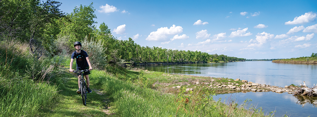
Situated along the west bank of the Missouri River, the 589-acre Cross Ranch State Park and adjacent 6,000-acre Cross Ranch Nature Preserve are one of the few areas in North Dakota to offer a true primitive outdoor experience. Over 16 miles of trail wind through Cross Ranch State Park and Nature Preserve. Trail posts identify the trail names.
Matah "River" Trail
Distance: 3.1 miles
Open to: hiking, mountain biking, cross-country skiing
This trail begins at the Visitor Center and loops around the park's main use areas. Along the river, interpretive signs describe the history, wildlife and geology of the area. The Matah Trail Self Guided Loop is the innermost loop covering 1.4 miles and takes up to an hour and a half to hike. Self-guided brochures are available at the trailhead or Visitor Center.
Ma-ak-oti "Old Village" Trail
Distance: 3.4 miles
Open to: hiking, snowshoeing
This trail is divided into two sections. The Upper Ma-ak-oti Trail starts from the Matah/Ma-ak-oti trail junction and continues to a creek flowing through a wooded ravine. The Lower Ma-ak-oti Trail begins at the Sanger trailhead and continues north, joining with the upper trail. Looping in parts, both sections of the trail wind through prairie bluffs and wooded channels, offering vistas of the Missouri River. Steep stairs without handrails are present on portions of the trail. Some areas may be muddy or impassable due to seasonal water fluctuations. This trail is open to hiking and snowshoeing. It is not groomed for skiing.
Cottonwood Trail/Gaines Trail
Distance: 5.3 miles
Open to: hiking, mountain biking, cross-country skiing
These connected trails (Cottonwood 3.3 miles, Gaines 2 miles) are accessed from the Matah Trail at the preserve boundary. They wind through the bottomland forest on preserve property and follow an old jeep track still used for scientific studies. Hikers are asked not to disturb areas marked with paint or flags as studies are still in progress. Groomed for skiing.
Levis Trail
Distance: 2.3 miles
Open to: hiking, mountain biking, cross-country skiing
A 2.3 mile route that winds through the Lewis and Clark backcountry on a 300-acre accreted "island" that joined the mainland following the completion of Garrison Dam. Groomed for skiing.
TNC Self-Guided Prairie Trail
Distance: 2.2 miles
Open to: hiking
This trail crosses over two miles of preserve prairie and wooded draws. A guidebook at the trailhead provides information on wildlife, plants and history. The trail is part of the Nature Conservancy bison pasture. The trailhead is located three-quarters of a mile north of the park entrance. Not open for skiing. Please note that Bison are present on this trail, remember to keep a safe distance and respect that they are wild animals.
Trail Maps
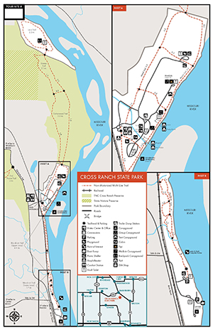
- A PDF Map of the trails is available here.
- All North Dakota State Park and Recreation Area trail information is available on the OuterSpatial App.
- Paper park maps are also available at the park.