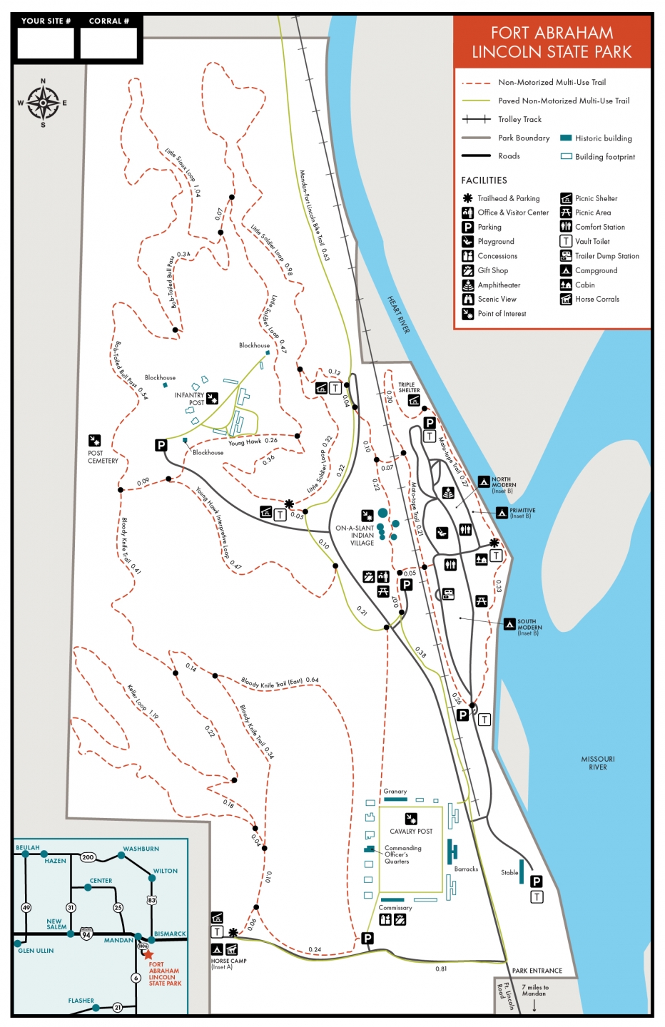
Fort Abraham Lincoln State Park's non-motorized trail system covers nearly 20 miles in a series of loops and several connecting segment trails that are open for hiking, biking and horseback riding. Most of the trail system surface is either grass, dirt or hard-packed single-track, with manageable grades with only a few steeper sections.
Scouts Trail System
Distance: 8.8 miles
Open to: hiking, snowshoeing, horseback riding, mountain biking
The non-motorized, multi-use Scouts Trail System covers 8.8 miles in a series of loops and connecting trails. Most of the surface is hard-packed single-track, with manageable grades and only a few steeper sections. The trail system joins the paved Mandan-Fort Lincoln Bike Trail at the north end of the main park road. The Scouts Trail System is open for hiking, biking and horseback riding. The Scouts Trail System can be accessed near the valley picnic shelter or the horse campground.
Little Soldier Loop Trail
Distance: 1.8 miles
Open to: hiking, snowshoeing, horseback riding, mountain biking
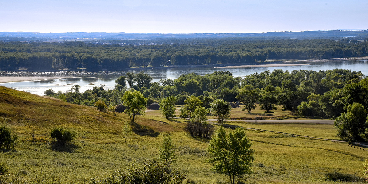
This trail segment starts at the Valley picnic shelter and meets up with the Young Hawk Interpretive Trail. The trail provides excellent vistas of the On-A-Slant Village, Missouri and Heart rivers and the city of Bismarck.
Young Hawk Interpretive Trail
Distance: 1.1 miles
Open to: hiking, snowshoeing, horseback riding, mountain biking
This trail starts and ends at the Valley picnic shelter. The trail contains several numbered posts and a corresponding trail guide describing the history, plant and wildlife of the area. Trail guides can be found at the Visitor Center.
Scattered Corn Trail
Distance: 0.4 miles
Open to: hiking, snowshoeing, mountain biking
This trail, named for the first female Corn Priest of the Mandan Tribe, starts along the Visitor Center parking lot and takes you to the On-A-Slant Indian Village. At the age of 12, Scattered Corn, learned the art of building an earthlodge and by the time she was 18, she had built a total of four earthlodges for her own use. In 1934, with the assistance of the Civilian Conservation Corps, she designed and reconstructed five earthlodges at the park.
Bob Tailed Pass
Distance: 1.1 miles
Open to: hiking, snowshoeing, horseback riding, mountain biking
A 1.1-mile trail that connects Little Soldier and Bloody Knife Trail Loops. The trail segment winds through prairie, shrublands and woodlands. The trail runs past the Post Cemetery.
Little Sioux Trail
Distance: 1 mile
Open to: hiking, snowshoeing, horseback riding, mountain biking
This trail loops visitors through the native prairie, buffaloberry and snowberry shrublands and green ash woodlands. The trail goes to the furthest reaches of the state park.
Bloody Knife Trail
Distance: 1.9 miles
Open to: hiking, snowshoeing, horseback riding, mountain biking
A 1.97-mile loop trail starting just south of the Post Cemetery running south to the horse corrals. A portion of this trail is designated for horse and hiking use only. The trail is close to the reconstructed Cavalry Post. Bikes are not allowed within the Cavalry Square. The scenic trail offers excellent bird watching opportunities.
Keller Loop Trail
Distance: 2 miles
Open to: hiking, snowshoeing, horseback riding, mountain biking
The newest trail to be added to the Fort Abraham Lincoln State Park trail system is the 2.02 mile Keller Loop. This multi-use trail connects to the Scouts Trail and winds through the rugged western hills of the park. The trail is named for the Keller family who sold this property to the State of North Dakota and continue to support the park.
Mato-tope Trail
Distance: 1.4 miles
Open to: hiking, snowshoeing, mountain biking
Beginning at the confluence of the Missouri and Heart Rivers, the trail loops the campground by running along the rivers and next to the old Northern Pacific Railroad line. The trail is named in honor of Mato-tope (Four Bears). He grew up in On-a-Slant and was the son of Chief Good Boy. Mato-tope was the second Mandan Chief named Four Bears.
Roughrider Trail
Distance: 22 miles
Open to: hiking, snowshoeing, mountain biking
Map
The Roughrider OHV Trail is located just south of Mandan along Highway 1806 and runs from Fort Abraham Lincoln State Park to Fort Rice Campground. At a total of 22 miles, the Roughrider Trail connects the park to wildlife management areas, Morton County parks, a gun range, boat ramps, and state historic sites. A trailhead and parking lot are located at the south end of Fort Abraham Lincoln State Park.
Trail Maps:
- View a PDF trail map.
- All North Dakota State Park and Recreation trail information is available on the OuterSpatial App.
- Paper park maps are also available at the park.