Turtle River State Park has a system of mountain biking, hiking, and interpretive trails. Winter users will find more than 7.5 miles of groomed cross-country ski trails, and plenty of opportunities for snowshoeing.
Fisher Loop
Distance: 0.65 miles
Open to: hiking, mountain biking, cross-country skiing, snowshoe
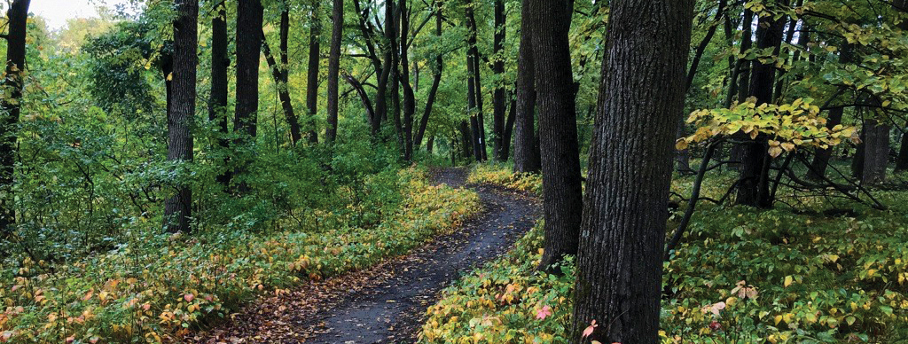
This wooded trail is accessed from the CCC Trail Head and returns to the same location. This trail crosses over the Turtle River and winds along the river corridor. It provides access to the River View and Timber trails and is groomed for cross-country skiing in winter.
Coneflower Loop
Distance: 0.6 miles
Open to: hiking, mountain biking, snowshoeing
This prairie and wooded trail is accessed from the via the Prairie Pass Trail. This trail loops through the prairie, into the wood line following the river corridor and returning to the prairie.
Timber Loop
Distance: 1.16 miles
Open to: hiking, mountain biking, cross-country skiing, snowshoe
This wooded trail is accessed from the CCC Trail Head via Fisher Loop and returns to the same location via River View. It begins along the Turtle River and meanders back through wooded hillsides. It is groomed along a modified route for cross-country skiing in winter.
Prairie Pass Trail
Distance: 0.64 miles
Open to: hiking, mountain biking, snowshoeing
This prairie trail is accessed from the CCC Trail Head via Fisher/ River View and ends at the Moose Head Trail accessed via the Woodland Lodge Trail Head. This trail meanders through the prairie, crossing the old entrance roadbed and features the old entrance booth as a resting location. Coneflower, Moose Head and River View trails can be accessed from this trail.
Moose Head Trail
Distance: 1.31 miles
Open to: hiking, mountain biking, snowshoeing
This scenic trail begins at the Woodland Lodge Trail Head and loops back to the Chalet and ball diamond. This trail is mostly wooded as it meanders along the creek corridor and features a foot-bridge crossing at the southeast end of the trail. Prairie Pass, River View, Eco Loop, and the Woodland Lodge can be accessed from this trail.
River View Trail
Distance: 1.05 miles
Open to: hiking, mountain biking, snowshoeing
This wooded trail is accessed from the CCC Trail Head via Fisher Loop and ends at the Woodland Lodge Trail Head. It begins by crossing the Turtle River and climbing the ridgeline that follows along the river with benches for viewing the river. The trail returns to the river corridor at the CCC Dam and ends at the Woodland Lodge. Prairie Pass, Moose Head and Timber trails can be accessed from this trail.
Eco Loop
Distance: 1.05 miles
Open to: hiking, cross-country skiing, snowshoe
This scenic trail begins at the Chalet Trail Head and ends on the Moosehead Trail. This trail features wooded hillsides, open prairies and views of the oxbow wetlands. Cattail trail access via this trail. A modified route is groomed for cross-country skiing in the winter.
Cattail Loop
Distance: 0.62 miles
Open to: hiking, snowshoeing
This trail is accessed via the Eco loop trail. It features a wildlife viewing station of the oxbow wetlands, boardwalk crossing of the oxbow, and finishes in the wooded hillside of the Eco loop trail.
Raven Ravine
Distance: 2.46 Miles
Open to: hiking, mountain biking, snowshoeing
This scenic trail begins at the CCC Trail Head and loops back to the Woodland Lodge. There are several connections to the campground, amphitheater, and the playground. This trail is mostly wooded as it meanders along the creek corridor, featuring a water crossing at the north end of the trail and two benches. Portions of this trail are groomed for Fat Tire Bikes and hiking in the winter.
Keystone Bridge
Distance: 0.84 Miles
Open to: hiking, mountain biking, snowshoeing
This scenic trail begins at the Trapper’s Rest Campground and ends at the Hollow’s Bridge parking area. There are several connections to the campground, Agassiz picnic area, and the Turtle River. This trail is wooded as it meanders along hillsides of the river corridor. Portions of this trail are groomed for Fat Tire Bikes and hiking in the winter.
Hollows
Distance: 1.74 Miles
Open to: hiking, mountain biking, snowshoeing, cross-country skiing
This scenic trail begins at the Visitor Center and ends at the Hillside Picnic Area with access to the Hollow’s Bridge parking and picnic area. This wooded trail winds through the hillsides and along the river corridor. Portions of this trail are groomed for Fat Tire Bikes and hiking, and others for cross-country skiing in the winter.
Trail Maps
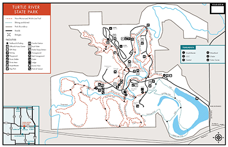
- A PDF Map of the summer trails is available here.
- All North Dakota State Park and Recreation Area trail maps are available in the OuterSpatial App.
- Paper park maps are also available at the park.